In light of tomorrow's rain forecast, I have already received a phone call from a viewer wondering about the timing of the forecast.
Well honestly, the models aren't close enough for me at this time to really rely on a consensus. My thoughts make me think the system is a little slower than the GFS, and this would allow rainfall to begin in the early morning. I do expect things to be clearing by the time you go to sleep Thursday night. A few models like the SREF have moisture sticking around through the evening, but I do believe the main instability and lift mechanisms will be out of the picture.
As this is a streched shortwave system, I would suspect some clouds to stick around behind the main push of the front. Friday looks like a Mostly Sunny day.
Temps will drop off a bit behind the front. Cold Air advection, CAA, will bring in stable conditions with a big of a clearing. 850 temps look like last week's rainfall event, but the difference is the direction of the wind flow. Cold Air Advection hinders uplift and development of moisture, but last week we had a nice Warm Air Advection area bringing in a swatch of moisture.
tcade@wdam.com
Wednesday, December 3, 2008

Tuesday, December 2, 2008
Cool Future...
We have already had mild Summer and Fall seasons, but what is in store for winter? Well our winter will officially begin on December 21, and plenty of difficult exist in forecasting weather several weeks in advance. Although we can make a good effort at distinguishing future trends, which will help us produce a future forecast.
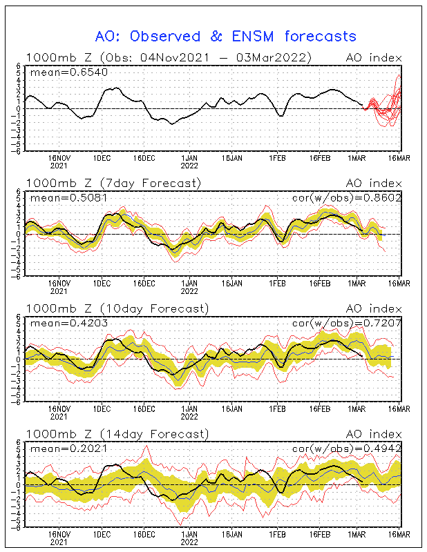
Right now I am noticing a below normal trend in temperatures for the next few weeks. Several long range models are producing a ridge/trough pattern across the U.S. This would deliver us cool temperatures as cP (continental polar) air will have a better opportunity to filter into our region. The Artic Oscillation, which brings cold air into the Eastern U.S., will be going extremely negative by the middle of December. This will allow the great possibility of us to be cooler than normal heading into the 1st day of Winter on Dec. 21. Also the NAO, North American Oscillation, looks to be going negative, which helps lock in the cold air for the Eastern Conus of the U.S.
Honestly, I am really interested to see what numbers we end up experiencing as they will be compared to these models right now.
Take care
tcade@wdam.com
Sunday, November 30, 2008
Snow
Got your attention didn't I?
A viewer recently called me to see if we were going to get snow tonight because he heard we were. Before I talk about snow here in South Mississippi I must communicate my careful wording. In my mind, several people can easily translate the word "snow" into the roads and ground covered in white, puffy and beautiful, snow, and they might also run to the grocery store to "gear up" for staying inside for a few days. In other words, I'm careful to use the word snow, but I will gladly be using more descriptive words while making a snow forecast so listen carefully.
Tonight we will have below feezing temperatures 1,000 to 2,000 feet above the ground, which is usually enough distance from the ground to melt any snow/ice from falling. But wilder things can still happen. In this case, if we still have enough moisture in the air, we might see a snowflake (or we might get lucky with 2 snowflakes).
This event will not be something to write home about, but I feel like I need to share my thoughts on this as many people have been discussing this lately.
Overall, we will be experiencing very cold upper-level temperatures through Tuesday night. Mondays high will be tough to roll above 50F, and temps will drop to the upper 20s Tuesday night.
Thanks for reading! Please email me your comments! And maybe go ahead and run to the store and get some hot chocolate anyway...it is going to be chilly. Hopefully you will see "the" snowflake fall.
tcade@wdam.com
A viewer recently called me to see if we were going to get snow tonight because he heard we were. Before I talk about snow here in South Mississippi I must communicate my careful wording. In my mind, several people can easily translate the word "snow" into the roads and ground covered in white, puffy and beautiful, snow, and they might also run to the grocery store to "gear up" for staying inside for a few days. In other words, I'm careful to use the word snow, but I will gladly be using more descriptive words while making a snow forecast so listen carefully.
Tonight we will have below feezing temperatures 1,000 to 2,000 feet above the ground, which is usually enough distance from the ground to melt any snow/ice from falling. But wilder things can still happen. In this case, if we still have enough moisture in the air, we might see a snowflake (or we might get lucky with 2 snowflakes).
This event will not be something to write home about, but I feel like I need to share my thoughts on this as many people have been discussing this lately.
Overall, we will be experiencing very cold upper-level temperatures through Tuesday night. Mondays high will be tough to roll above 50F, and temps will drop to the upper 20s Tuesday night.
Thanks for reading! Please email me your comments! And maybe go ahead and run to the store and get some hot chocolate anyway...it is going to be chilly. Hopefully you will see "the" snowflake fall.
tcade@wdam.com
Saturday, November 29, 2008
Love Weather
I love my job.
I love weather.
I love the rainfall.
In our ever-changing weather pattern, things in our weather department never get old. A new day of work means a new day of weather and patterns to study and forecast. Our rainfall here in the last 36 hours has brought many of us back up to our average mark of rainfall for the whole month of November. No a hurricane did not pass through South Mississippi, but a wet and juicy stationary front claimed residence in our district. This stationary boundary has now moved out of the way, but we still have a couple of cold fronts to push on through. In fact, we could see our coldest High temperature since Jan. '08 this upcoming Monday. Our records at the station show we haven't seen a high of 48 since this past January. My forecast for Monday...48.
Feel free to email me your thoughts at tcade@wdam.com
tcade@wdam.com
I love weather.
I love the rainfall.
In our ever-changing weather pattern, things in our weather department never get old. A new day of work means a new day of weather and patterns to study and forecast. Our rainfall here in the last 36 hours has brought many of us back up to our average mark of rainfall for the whole month of November. No a hurricane did not pass through South Mississippi, but a wet and juicy stationary front claimed residence in our district. This stationary boundary has now moved out of the way, but we still have a couple of cold fronts to push on through. In fact, we could see our coldest High temperature since Jan. '08 this upcoming Monday. Our records at the station show we haven't seen a high of 48 since this past January. My forecast for Monday...48.
Feel free to email me your thoughts at tcade@wdam.com
tcade@wdam.com
Friday, November 28, 2008
Rain
Here in Eastabuchie we have received 0.19" by 9:30am, which is a small amount compared to the heavy 0.54" already seen in Jackson.
If you have watched this mornings newscast, you've noticed the radar imagine this morning has produced a long line of rain along the I-20 corridor. This is all due to a stationary boundary bringing plenty of moisture and colliding with a moderate upper-level jet streak.
I'll be keeping track of rain totals as we continue to experience a rainy 48 hours (or more).
If you have watched this mornings newscast, you've noticed the radar imagine this morning has produced a long line of rain along the I-20 corridor. This is all due to a stationary boundary bringing plenty of moisture and colliding with a moderate upper-level jet streak.
I'll be keeping track of rain totals as we continue to experience a rainy 48 hours (or more).
Thursday, November 27, 2008
Warm Morning Temps
Inside your household you might be smelling turkey and sweet potatoes, but after stepping outside you might be able to sense precipitation on our door step here in the Pine Belt. Showers have already started breaking out across Louisiana, and I expect the showers to slowly progress eastward within the next 24 hours.
A boundary will sit down over Central Mississippi through Saturday night. This will aid in delivering our rain through Friday because the boundary will continue to pump moisture in South Mississippi. The mix of the moisture and upper level jet will allow enough available lift to create the forecast showers.
On Sunday, I expect a large cold front to push the stationary boundary southward and give way to very chilly temperatures. The GFS is still forecasting -10C 850mb temps, which is the coldest of the Fall season, but the European model is persistently producing only -4C 850 temps. In the end, Monday could be coldest day we have experienced this season.
Enjoy your thanksgiving!
God Bless
tcade@wdam.com
A boundary will sit down over Central Mississippi through Saturday night. This will aid in delivering our rain through Friday because the boundary will continue to pump moisture in South Mississippi. The mix of the moisture and upper level jet will allow enough available lift to create the forecast showers.
On Sunday, I expect a large cold front to push the stationary boundary southward and give way to very chilly temperatures. The GFS is still forecasting -10C 850mb temps, which is the coldest of the Fall season, but the European model is persistently producing only -4C 850 temps. In the end, Monday could be coldest day we have experienced this season.
Enjoy your thanksgiving!
God Bless
tcade@wdam.com
Wednesday, November 26, 2008
New Episode of Tanner Cade Hour

The newest episode of the Tanner Cade Hour is up! Please feel free to check out the 5th episode of the season.
Subscribe to:
Posts (Atom)

 Posts
Posts