It's a little early to be 100% sure about this, but keep an eye on our weather next Tuesday. There's a chance for strong if not severe storms. Pay close attention to the forecast Sunday and Monday.
-Nick Ortego
Friday, December 5, 2008

Cool Weekend...Rain Coming
Honestly, this morning felt very cold as I headed into the station. Wind Chill temp dropped to 20° this morning at PIB airport, which was 10° below the air temp.
Temperatures will be our main concern this weekend as temps will stay below average for this time of year. In fact, this December has already started off to be a cool and wet month so far.
Wet conditions will come back into play next week. In fact, Tuesday could potentially be a day of heavy rain. A strong Low Pressure system will sink into the the Mississippi River Valley and create an ample amount of instability throughout the Southeast. The ECMWF model actually has this setup lasting through Thursday. So could rain exist for a majority of our week?
I am also considering a thunderstorm event on Tuesday. A moderate amount of lift, instability, and moisture will be available for heavy rain and thunderstorms. The severe weather threat seems low at this point, but the potential for wind and hail is my first concern for next Tuesday.
Thanks for reading through our blog today!
tcade@wdam.com
Temperatures will be our main concern this weekend as temps will stay below average for this time of year. In fact, this December has already started off to be a cool and wet month so far.
Wet conditions will come back into play next week. In fact, Tuesday could potentially be a day of heavy rain. A strong Low Pressure system will sink into the the Mississippi River Valley and create an ample amount of instability throughout the Southeast. The ECMWF model actually has this setup lasting through Thursday. So could rain exist for a majority of our week?
I am also considering a thunderstorm event on Tuesday. A moderate amount of lift, instability, and moisture will be available for heavy rain and thunderstorms. The severe weather threat seems low at this point, but the potential for wind and hail is my first concern for next Tuesday.
Thanks for reading through our blog today!
tcade@wdam.com
Thursday, December 4, 2008
Rain Exit Right, Cold Air Enter Left
As of 3:15pm Thursday, we are done with most of the rain. The clouds are still in place and a light rain or mist is possible, but it will be so light you will not find it on radar. But lets forget about the rain, that's the past.
The cold air, accompanied by wind, is what the future holds, and it's coming in strong from the NW. Overnight, expect temps to drop into the lower 30's and winds to blow around 10-15 mph.
Tomorrow it will be a prettier day, but still cool with highs in the low to mid 50s.
-Nick Ortego
The cold air, accompanied by wind, is what the future holds, and it's coming in strong from the NW. Overnight, expect temps to drop into the lower 30's and winds to blow around 10-15 mph.
Tomorrow it will be a prettier day, but still cool with highs in the low to mid 50s.
-Nick Ortego
Rain Totals...so far
As of 7:10am
Here in Eastabuchie: 0.57"
Grubbs Ford in Columbia: 0.57"
Pine Belt Airport: 0.60"
Bobby Chain (Hattiesburg): 0.54"
Jackson, MS: 1.03"
Meridian: 0.89"
Bad news: you might have to walk outside in the rain this morning
Good news: The rain is moving through relatively quickly.
The front is pushing through quickly as we see the rain totals nearing between 0.5" to 1.0". My biggest story is rain in this morning, but our weather will be clearing out as the day progresses. By this evening, some of our western counties (Walthall, Marion, Jefferson Davis, Covington, and Smith) might actually see a beautiful sunset. Some low level clouds could still be hanging around for the rest of the viewing area. Temps won't be warm at all. Our high for the next few days tops out in the mid-50s.
Here in Eastabuchie: 0.57"
Grubbs Ford in Columbia: 0.57"
Pine Belt Airport: 0.60"
Bobby Chain (Hattiesburg): 0.54"
Jackson, MS: 1.03"
Meridian: 0.89"
Bad news: you might have to walk outside in the rain this morning
Good news: The rain is moving through relatively quickly.
The front is pushing through quickly as we see the rain totals nearing between 0.5" to 1.0". My biggest story is rain in this morning, but our weather will be clearing out as the day progresses. By this evening, some of our western counties (Walthall, Marion, Jefferson Davis, Covington, and Smith) might actually see a beautiful sunset. Some low level clouds could still be hanging around for the rest of the viewing area. Temps won't be warm at all. Our high for the next few days tops out in the mid-50s.
Wednesday, December 3, 2008
Rain Timing Update
At 4:00pm Wednesday, you can see the line of showers through Arkansas and Texas coming together nicely. By our 10:00pm newscast, I expect the line of showers to look impressive, but still be hours from the Pine Belt. Models suggest that rain will be approaching our western counties in the early morning hours of 4:00-7:00 o'clock. This means we will likely be dealing with some type of rainfall throughout the morning commute. Intense severe weather is not likely, but isolated pockets of wind, heavy rain, and lightning can not be ruled out.
Once the front pushes through expect much cooler air on the other side. Thursday nights low is 31!
nortego@wdam.com
Once the front pushes through expect much cooler air on the other side. Thursday nights low is 31!
nortego@wdam.com
Rain Timing
In light of tomorrow's rain forecast, I have already received a phone call from a viewer wondering about the timing of the forecast.
Well honestly, the models aren't close enough for me at this time to really rely on a consensus. My thoughts make me think the system is a little slower than the GFS, and this would allow rainfall to begin in the early morning. I do expect things to be clearing by the time you go to sleep Thursday night. A few models like the SREF have moisture sticking around through the evening, but I do believe the main instability and lift mechanisms will be out of the picture.
As this is a streched shortwave system, I would suspect some clouds to stick around behind the main push of the front. Friday looks like a Mostly Sunny day.
Temps will drop off a bit behind the front. Cold Air advection, CAA, will bring in stable conditions with a big of a clearing. 850 temps look like last week's rainfall event, but the difference is the direction of the wind flow. Cold Air Advection hinders uplift and development of moisture, but last week we had a nice Warm Air Advection area bringing in a swatch of moisture.
tcade@wdam.com
Well honestly, the models aren't close enough for me at this time to really rely on a consensus. My thoughts make me think the system is a little slower than the GFS, and this would allow rainfall to begin in the early morning. I do expect things to be clearing by the time you go to sleep Thursday night. A few models like the SREF have moisture sticking around through the evening, but I do believe the main instability and lift mechanisms will be out of the picture.
As this is a streched shortwave system, I would suspect some clouds to stick around behind the main push of the front. Friday looks like a Mostly Sunny day.
Temps will drop off a bit behind the front. Cold Air advection, CAA, will bring in stable conditions with a big of a clearing. 850 temps look like last week's rainfall event, but the difference is the direction of the wind flow. Cold Air Advection hinders uplift and development of moisture, but last week we had a nice Warm Air Advection area bringing in a swatch of moisture.
tcade@wdam.com
Tuesday, December 2, 2008
Cool Future...
We have already had mild Summer and Fall seasons, but what is in store for winter? Well our winter will officially begin on December 21, and plenty of difficult exist in forecasting weather several weeks in advance. Although we can make a good effort at distinguishing future trends, which will help us produce a future forecast.
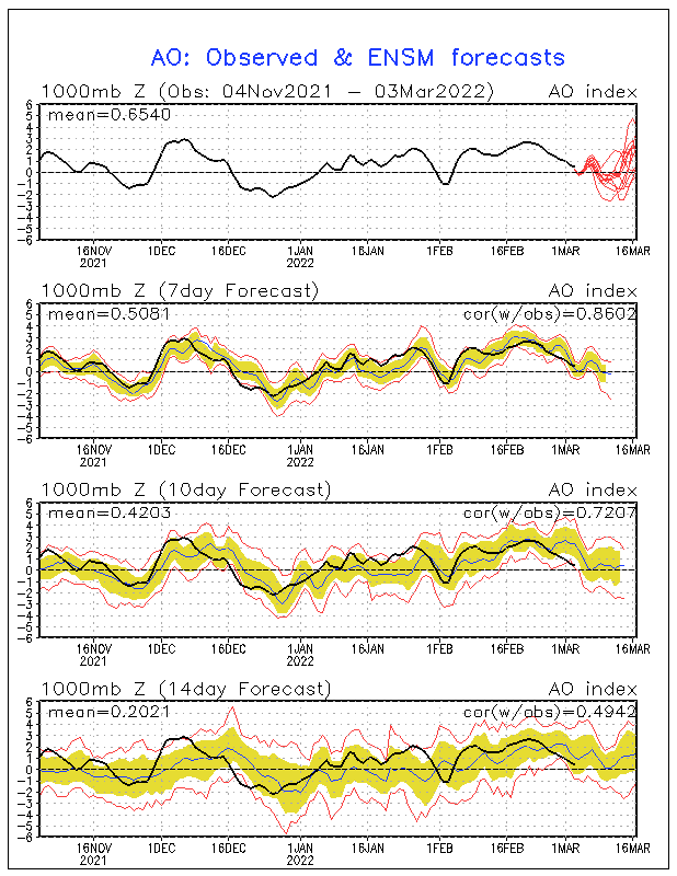
Right now I am noticing a below normal trend in temperatures for the next few weeks. Several long range models are producing a ridge/trough pattern across the U.S. This would deliver us cool temperatures as cP (continental polar) air will have a better opportunity to filter into our region. The Artic Oscillation, which brings cold air into the Eastern U.S., will be going extremely negative by the middle of December. This will allow the great possibility of us to be cooler than normal heading into the 1st day of Winter on Dec. 21. Also the NAO, North American Oscillation, looks to be going negative, which helps lock in the cold air for the Eastern Conus of the U.S.
Honestly, I am really interested to see what numbers we end up experiencing as they will be compared to these models right now.
Take care
tcade@wdam.com
Subscribe to:
Posts (Atom)

 Posts
Posts